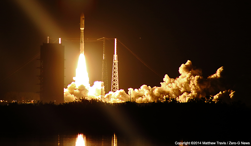
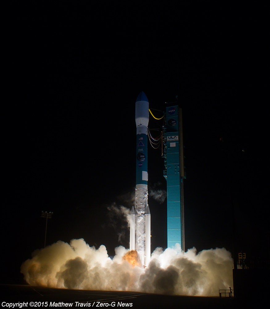
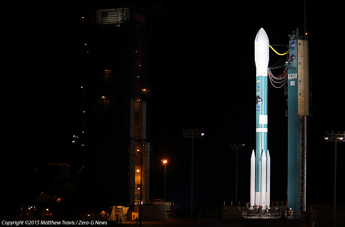
Blazing a trail through a cloudy California morning, a United Launch Alliance Delta II rocket successfully deployed NASA’s Soil Moisture Active Passive (SMAP spacecraft into polar orbit this morning on one of the venerable launch vehicle’s final missions. After delays this week due to strong high altitude winds, Delta blasted off at 6:22 a.m. PST from Space Launch Complex 2-West at Vandenberg Air Force Base to begin its 57 minute climb to orbit.
Check out our SMAP Launch Photo Gallery!
Visit our collection of SMAP Mission Videos!
With its Aerojet Rocketdyne RS-27A first stage provided an additional boost by three ATK-manufactured solid rocket motors, the vehicle leapt off the launch pad and quickly disappeared into low clouds that hung over the launch site. The clouds completely obscured the view for the public, many of whom stopped roadside outside of the military complex to watch.
The rocket quickly raced southward, jettisoning the solid boosters a minute and a half after launch. A couple minutes later, the liquid fueled first stage drained the last of its kerosene and liquid oxygen propellants and separated from the Aerojet Rockedyne AJ10-118K hypergolic restartable second stage.
About 57 minutes after liftoff, SMAP separated from the rocket’s second stage into an initial 411- by 425-mile orbit. The spacecraft then deployed its solar array and established communications with ground controllers, confirming the spacecraft survived the trip in excellent health.
“The launch of SMAP completes an ambitious 11-month period for NASA that has seen the launch of five new Earth-observing space missions to help us better understand our changing planet,” said NASA Administrator Charles Bolden. “Scientists and policymakers will use SMAP data to track water movement around our planet and make more informed decisions in critical areas like agriculture and water resources.”
“Congratulations to the NASA Launch Services Program team, JPL and all of our mission partners on today’s successful launch of the SMAP satellite,” said Jim Sponnick, ULA vice president, Atlas and Delta Programs. “It is our honor to launch this important Earth science mission to help scientists observe and predict natural hazards, and improve our understanding of Earth’s water, energy and carbon cycles.”
SMAP and its ground systems will be commissioned over the next three months to ensure they are fully functional and are ready to begin routine science data collection. A key milestone will be the deployment of the spacecraft’s instrument boom and 20-foot diameter reflector antenna. The observatory will be maneuvered to its final 426-mile, near-polar operational orbit, and the antenna will spin up to 14.6 revolutions per minute.
“Congratulations to the NASA Launch Services Program team, JPL and all of our mission partners on today’s successful launch of the SMAP satellite,” said Jim Sponnick, ULA vice president, Atlas and Delta Programs. “It is our honor to launch this important Earth science mission to help scientists observe and predict natural hazards, and improve our understanding of Earth’s water, energy and carbon cycles.”
SMAP is embarking on a three-year mission that will peer below Earth’s surface to expand our understanding of a key component of the Earth system that links the water, energy and carbon cycles driving our living planet. SMAP also will detect whether the ground is frozen or thawed. Detecting variations in the timing of spring thaw and changes in the length of the growing season will help scientists more accurately account for how much carbon plants are removing from Earth’s atmosphere each year, critical information as scientists and government around the world work to figure out how to cope and combat the effects of climate change.
“The next few years will be especially exciting for Earth science thanks to measurements from SMAP and our other new missions,” said Michael Freilich, director of the Earth Science Division of NASA’s Science Mission Directorate in Washington. “Each mission measures key variables that affect Earth’s environment. SMAP will provide new insights into the global water, energy, and carbon cycles. Combining data from all our orbiting missions will give us a much better understanding of how the Earth system works.”
SMAP Mission Background
Soil moisture controls the partitioning of available energy into sensible and latent heat fluxes across regions where the evaporation regime is, at least intermittently, water-limited (as opposed to energy-limited). Since the fluxes of sensible and latent heat and moisture at the base of the atmosphere influence the evolution of weather, soil moisture is often a significant factor in the performance of atmospheric models, both in weather and in climate applications.
“SMAP will improve the daily lives of people around the world,” said Simon Yueh, SMAP project scientist at NASA’s Jet Propulsion Laboratory (JPL) in Pasadena, California. “Soil moisture data from SMAP has the potential to significantly improve the accuracy of short-term weather forecasts and reduce the uncertainty of long-term projections of how climate change will impact Earth’s water cycle.”
The goal of the SMAP mission is to establish a satellite observatory in a near-polar, sun-synchronous Earth orbit to collect a 3-year dataset that will be used to determine the moisture content of the upper soil and its frozen or thawed state, with global measurements every 3 days. This is accomplished using an instrument that combines an L-band radar and an L-band radiometer, which share a rotating 6-m-aperture reflector antenna that scans a wide 1000-km swath as the observatory orbits the Earth.
The radiometer provides “passive” measurements of the microwave emission from the upper soil with a spatial resolution of about 40 km, and is more sensitive to near-surface soil moisture and less sensitive to the effects of surface roughness and vegetation than the radar.

The radar makes “active” backscatter measurements of the surface, and the ground processing system performs the synthetic aperture radar processing to achieve a spatial resolution of 3 km across about 70% of the swath in its high-resolution mode. Utilizing a combination of the active and passive datasets provides greater accuracy and spatial resolution in measuring moisture in the upper 5 cm of soil than is possible with either of the individual instruments alone.
SMAP observations of soil moisture and freeze/thaw state from space will allow significantly improved estimates of water, energy, and carbon transfers between the land and atmosphere. Soil moisture measurements are directly applicable to flood assessment and drought monitoring. SMAP observations can help mitigate these natural hazards, resulting in potentially great economic and social benefits. SMAP observations of soil moisture and freeze/thaw timing will also reduce a major uncertainty in quantifying the global carbon balance by helping to resolve an apparent missing carbon sink on land at boreal latitudes.
Science Objectives
The science objectives of the SMAP project are captured by five specific goals:
- Understand processes that link the terrestrial water, energy, and carbon cycles,
- Estimate global water and energy fluxes at the land surface,
- Quantify net carbon flux in boreal landscapes,
- Enhance weather and climate forecast skill, and
- Develop improved flood prediction and drought monitoring capability.
SMAP measurements address a wide variety of diverse applications, including:
- Weather forecasting through initialization of numerical weather prediction models
- Seasonal climate forecasting through use of soil moisture as model initial and boundary conditions
- Agricultural and hydrological drought monitoring through mapping of soil moisture deficits
- Flood and flash flood forecasting and hazards mitigation through soil moisture-based flood guidance
- Agricultural productivity and early famine warning through assessment of crop water stress
- Human health through monitoring and prediction of heat stress and conditions for waterborne diseases
- National security through assessment of terrain trafficability and density altitude for air transport
During its science operations, SMAP will return an average volume of 135 GB per day of science data to be delivered to the science data processing facility. SMAP does not have an onboard Global Positioning System (GPS) receiver and the associated ephemeris knowledge because the large instrument reflector in the zenith direction obscures GPS visibility.
SMAP will observe the Earth from a sun-synchronous, near-circular science orbit with an equator-crossing altitude near 426 miles and an ascending node at 6 PM local mean solar time. At this altitude, a sun-synchronous orbit has an inclination of about 98.12º and an orbit period of 98.46 minutes. The science orbit altitude has been selected to allow near-global coverage of the Earth to be obtained in 3 days (44 orbits) with an instrument swath of about 1000 km and a ground track that repeats exactly in 8 days (117 orbits). This repeat pattern provides even coverage of the planet with an ideal longitude spacing between ground tracks at the equator of 3.077 degrees.
The terminator orbit was selected to allow soil moisture measurements near the morning terminator, where ionospheric effects and land–atmosphere thermal gradients are minimized. This design also minimizes thermal variations on the instrument and simplifies the spacecraft design. The 6 PM ascending node was selected so that the annual eclipse season (about 12 weeks per year from mid May to early August) occurs near the southern part of the orbit, and this minimizes thermal effects on freeze/thaw measurements in the northern hemisphere. The maximum eclipse duration is about 18.6 minutes.
The altitude for the science orbit repeat pattern of 117 orbits in 8 days is selected slightly above the altitude for an exact 3-day repeat pattern so that the ground track walks to the west and fills in the gap between consecutive orbits.
At the end of its useful life, the observatory will be maneuvered to a lower disposal orbit and decommissioned to a functional state that prevents interference with other missions.The observatory is maneuvered to the lower disposal orbit to reduce its orbital lifetime and passivated (energy sources depleted to the extent allowed by the design) to reduce the risk of explosion or fragmentation if struck by orbital debris. The disposal orbit has been designed to ensure that the observatory re-enters the atmosphere within 15.5 years.

SMAP Instruments
SMAP’s radar uses a microwave frequency of 1215 to 1300 megahertz (MHz) in a part of the electromagnetic spectrum known as the L-band. The radar transmits almost 3,000 pulses of microwaves a second and receives the signals that bounce back from Earth, called backscatter. Microwaves at this frequency are able to penetrate a few inches or more into the soil before they rebound.
Water – including water in soil – responds differently than dry soil does to microwaves. Water changes the strength of backscatter and microwaves’ polarization (the orientation of the electrical field of the microwaves). Therefore, backscatter from moister soil is stronger and is polarized differently than backscatter from dryer soil. The extent of the difference allows scientists to distinguish the amount of soil moisture. SMAP’s radar emits pulses with two different polarizations, horizontal and vertical, to make a more complete measurement of this effect.
The radar achieves the mission’s high resolution requirements by a technique called synthetic aperture radar (SAR) processing. SAR “synthesizes” a virtual antenna many kilometers long through complex signal processing of Doppler shifts in the backscatter. The Doppler shifts occur because returning microwaves from a target in front of the spacecraft appear to be compressed by the spacecraft’s movement toward them, whereas returns from a target receding behind SMAP appear to be spread out.
SAR processing is commonly used in scientific research and space missions to produce topographic-like maps of terrain; however SMAP’s SAR lacks the capability to produce these types of images. Instead, it produces “maps” of backscatter at high spatial resolution. SMAP is the first mission to use a SAR in connection with a rotating mesh antenna.
Besides providing soil moisture measurements, the radar data will also provide information on whether the soil is frozen or thawed – another key science objective. When water in soil freezes, radar backscatter is greatly reduced, making the change of state readily observable from space.
Like the radar, SMAP’s radiometer detects differences in microwaves that are caused by water in soil; but the radiometer measures Earth’s natural microwave emissions at the frequency of 1.4 gigahertz, in the L-band. Around the globe, the most striking difference in these natural emissions is between water and land surfaces. A desert emits microwaves at about three times the rate that a lake does. Because the difference is so large, even a small amount of moisture in soil causes a change that a radiometer can measure accurately.
The Antenna
To enable the mission to meet its accuracy and resolution needs while covering the globe every three days or less, SMAP’s rotating antenna is about 20 feet (6 meters) in diameter. SMAP’s Reflector Boom Assembly (RBA) is an advanced, low-mass, deployable reflector system – the first spinning and precision mass balanced mesh reflector with an ultracompact stowage volume and a precision surface. It is the first use of such a system in a spaceborne instrument that jointly supports radar and radiometric measurements for Earth science. It is also the first use of a deployable mesh antenna in a rotating spaceborne instrument, rotating at 14.6 revolutions per minute, or one rotation in fewer than four seconds. The RBA enables SMAP to meet its measurement requirements for high accuracy and spatial resolution and to achieve global coverage every two or three days while still using only a single small observatory that weighs just over a U.S. ton (1,000 kilograms).
The designers chose a flexible mesh antenna because it must fold into a very compact stowed volume of 1 foot by 4 feet (30 by 120 centimeters) for launch.
The SMAP Applications Program
The SMAP Applications Program was created in 2007 to locate and engage groups that were likely to find innovative ways to use the mission’s data for societal benefit. The program now has more than 300 partners. Its extensive pre-launch activities over the years have set a new standard for engaging users during the development of a NASA mission.
The SMAP Applications Working Group, with a wide and inclusive membership, develops plans for SMAP applications and identifies future potential users of SMAP data. One important set of data users is the SMAP Early Adopters: individuals and organizations that are already aware of a clearly defined need for the kind of data SMAP will provide. Early Adopters use their own resources (funding, personnel, facilities, etc.) to conduct research with simulated SMAP data provided by the mission. The research is aimed at preparing them to integrate the real data into their own programs quickly, once it is available, and also at helping SMAP mission staff assure that the mission’s data products meet user needs. Early Adopters work closely with SMAP team members, interacting in workshops, tutorials and other events.
In addition, the Delta II delivered four educational cubesats as part of NASA’s Educational Launch of Nanosatellite (ELaNa) initiative.
ULA’s next launch is the Atlas V Magnetospheric Multiscale (MMS) mission for NASA, scheduled for March 12 from Space Launch Complex-41 from Cape Canaveral Air Force Station, Florida.